File:02-eglise de la Sainte-Vierge de Selommes.jpg

Size of this preview: 400 × 600 pixels. Other resolutions: 160 × 240 pixels | 320 × 480 pixels | 512 × 768 pixels | 682 × 1,024 pixels | 2,304 × 3,456 pixels.
Original file (2,304 × 3,456 pixels, file size: 4.59 MB, MIME type: image/jpeg)
Summary
| Description |
Français : 11e siècle ; 12e siècle
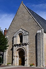
La construction de l'église paraît remonter au 12e siècle, avec des modifications postérieures. Cette église comprend une nef et un choeur, non voûtés, avec entraits sculptés à leurs extrémités (têtes d'animaux, feuillages, personnages) et aiguilles apparents. Le portail ouest présente des caractéristiques du 12e siècle : colonnes sur bases avec chapiteaux ornés de feuillages, arc en plein cintre surmonté d'un second arc avec cordon chanfreiné. Sur le côté nord du choeur s'élève la tour du clocher, de plan carré. La salle basse du clocher communiquait autrefois avec le choeur et était voûtée en coupole, sur pendentifs, et décorée de peintures. A la suite d'une catastrophe, la voûte s'est effondrée. Un pan de bois fut ensuite monté vers le milieu pour porter une nouvelle charpente et le beffroi. Le reste a été utilisé comme sacristie. Le mur oriental avec pignon présente un décor de petits moëllons ayant différentes dispositions d'appareillage. A la partie inférieure, les moëllons sont disposés horizontalement. Au-dessus, ils sont disposés en "opus spicatum". Puis, ils sont carrés et posés sur l'angle. Ensuite, la décoration devient plus compliquée, formée de petits moëllons carrés entourés d'hexagones allongés. Plus haut, ce sont des petits losanges debout, puis couchés. Au-dessus de ce bandeau, ils prennent une forme triangulaire et sont posés sur la pointe. Losanges debout puis couchés terminent le décor du pignon. |
| Date | |
| Source | Own work |
| Author | Chatmouettes |
| Camera location | | View this and other nearby images on: OpenStreetMap |
|---|
|
This building is inscrit au titre des monuments historiques de la France. It is indexed in the base Mérimée, a database of architectural heritage maintained by the French Ministry of Culture, under the reference PA00098603
|
Licensing
I, the copyright holder of this work, hereby publish it under the following license:
This file is licensed under the Creative Commons Attribution-Share Alike 3.0 Unported license.
- You are free:
- to share – to copy, distribute and transmit the work
- to remix – to adapt the work
- Under the following conditions:
- attribution – You must give appropriate credit, provide a link to the license, and indicate if changes were made. You may do so in any reasonable manner, but not in any way that suggests the licensor endorses you or your use.
- share alike – If you remix, transform, or build upon the material, you must distribute your contributions under the same or compatible license as the original.

|
This image was uploaded as part of Wiki Loves Monuments 2012.
|
File history
Click on a date/time to view the file as it appeared at that time.
| Date/Time | Thumbnail | Dimensions | User | Comment | |
|---|---|---|---|---|---|
| current | 15:55, 17 September 2012 | | 2,304 × 3,456 (4.59 MB) | Chatmouettes | User created page with UploadWizard |
File usage
The following 3 pages use this file:
Global file usage
The following other wikis use this file:
- Usage on ca.wikipedia.org
- Usage on ceb.wikipedia.org
- Usage on ce.wikipedia.org
- Usage on diq.wikipedia.org
- Usage on en.wikipedia.org
- Usage on eo.wikipedia.org
- Usage on es.wikipedia.org
- Usage on eu.wikipedia.org
- Usage on fr.wikipedia.org
- Usage on hu.wikipedia.org
- Usage on it.wikipedia.org
- Usage on pl.wikipedia.org
- Usage on pt.wikipedia.org
- Usage on ro.wikipedia.org
- Usage on sk.wikipedia.org
- Usage on sl.wikipedia.org
- Usage on sv.wikipedia.org
- Usage on tt.wikipedia.org
- Usage on uk.wikipedia.org
- Usage on uz.wikipedia.org
- Usage on vec.wikipedia.org
- Usage on zh-min-nan.wikipedia.org
- Usage on zh.wikipedia.org