File:1784 Bocage Map of The Bosphorus and the City of Byzantium - Istanbul - Constantinople - Geographicus - Bosphorus-white-1793.jpg
Size of this preview: 800 × 544 pixels. Other resolutions: 320 × 218 pixels | 640 × 436 pixels | 1,024 × 697 pixels | 1,280 × 871 pixels | 2,000 × 1,361 pixels.
Original file (2,000 × 1,361 pixels, file size: 665 KB, MIME type: image/jpeg)
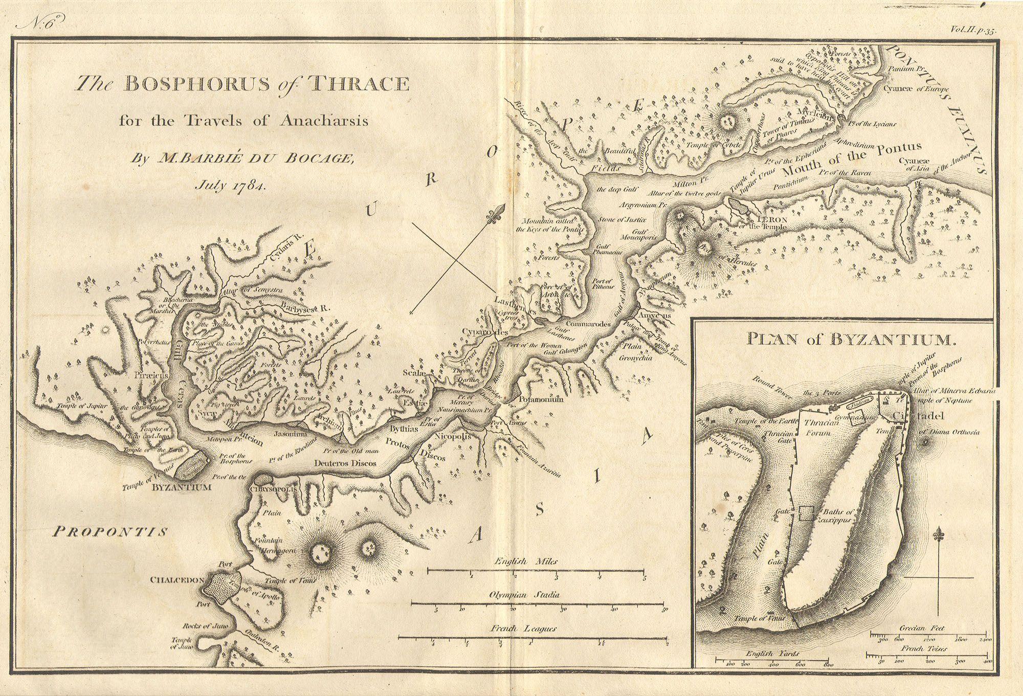
| Bosphorus and the city of Byzantium. | ||||||
|---|---|---|---|---|---|---|
| Artist | ||||||
| Title |
Bosphorus and the city of Byzantium. |
|||||
| Description |
English: This lovely map, depicting the Bosphorus and the city of Byzantium, was prepared by Jean-Denis Barbié du Bocage in 1784 for the “Travels of Anarcharsis”. The map shows the narrow naval passage from the Propontis (Sea of Marmara) to the Pontus Euxinus (Black Sea). There is a beautiful inset plan of the Horn of Byzantium. Today Byzantium is Istanbul, but the horn and many of the ancient structures still exists. This map also shows the area in considerable topographical detail. |
|||||
| Date | 1784 | |||||
| Dimensions | height: 8.5 in (21.5 cm); width: 12 in (30.4 cm) | |||||
| Accession number |
Geographicus link: Bosphorus-white-1793 |
|||||
| Source/Photographer |
|
|||||
| Permission (Reusing this file) |
|
|||||
| Other versions | ||||||

File history
Click on a date/time to view the file as it appeared at that time.
| Date/Time | Thumbnail | Dimensions | User | Comment | |
|---|---|---|---|---|---|
| current | 20:46, 15 March 2011 | | 2,000 × 1,361 (665 KB) | BotMultichill | {{subst:User:Multichill/Geographicus |link=http://www.geographicus.com/P/AntiqueMap/Bosphorus-white-1793 |product_name=1784 Bocage Map of The Bosphorus and the City of Byzantium / Istanbul / Constantinople |map_title=Bosphorus and the city of Byzantium. | |
File usage
The following 2 pages use this file:
Global file usage
The following other wikis use this file:
- Usage on ar.wikipedia.org
- Usage on arz.wikipedia.org
- Usage on ast.wikipedia.org
- Usage on az.wikipedia.org
- Usage on ca.wikipedia.org
- Usage on cs.wikipedia.org
- Usage on el.wikipedia.org
- Usage on en.wikipedia.org
- Usage on eo.wikipedia.org
- Usage on eu.wikipedia.org
- Usage on gl.wikipedia.org
- Usage on he.wikivoyage.org
- Usage on hu.wikipedia.org
- Usage on hy.wikipedia.org
- Usage on it.wikipedia.org
- Usage on nap.wikipedia.org
- Usage on pt.wikipedia.org
- Usage on ro.wikipedia.org
- Usage on sk.wikipedia.org
- Usage on tr.wikipedia.org
- Usage on zh.wikipedia.org