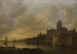
File:2011-03-26 Aschaffenburg 014 Schloss Johannisburg, Staatsgalerie, Jan van Goyen - Der Valkhof in Nijmegen (6091270484).jpg

Original file(3,644 × 2,572 pixels, file size: 5.63 MB, MIME type: image/jpeg)

This is a file from the Wikimedia Commons. Information from its description page there is shown below.
Commons is a freely licensed media file repository. You can help.

Summary

Jan van Goyen: The Valkhof in Nijmegen  wikidata:Q30057406 reasonator:Q30057406
Artist
Jan van Goyen  (1596–1656)  wikidata:Q315996 s:nl:Hoofdportaal:Beeldende kunst/Schilderkunst/Nederland/Jan van Goyen
 
Jan van Goyen
Alternative names
Jan Josefsz. van Goyen, Jan Josephsz. van Goyen
Description Dutch painter and drawer
Date of birth/death 13 January 1596 Edit this at Wikidata 27 April 1656 Edit this at Wikidata
Location of birth/death Leiden The Hague
Work period 1620–1656
Work location
Leiden, Hoorn, Leiden (ca. 1610–1615), France (1615–1616), Haarlem (1617), Leiden (1618–1632), The Hague (1632–1634), Haarlem (1634), The Hague (1635–1656)
Authority file
artist QS:P170,Q315996
image of artwork listed in title parameter on this page
Title
German:
Der Valkhof in Nijmegen Edit this at Wikidata

The Valkhof in Nijmegen
title QS:P1476,de:"Der Valkhof in Nijmegen Edit this at Wikidata"
label QS:Lde,"Der Valkhof in Nijmegen Edit this at Wikidata"
label QS:Len,"The Valkhof in Nijmegen"
Object type painting Edit this at Wikidata
Genre landscape art Edit this at Wikidata
Description
Der Valkhof in Nijmegen
Date 1646 Edit this at Wikidata
Dimensions height: 109 cm (42.9 in) Edit this at Wikidata; width: 152.4 cm (60 in) Edit this at Wikidata
dimensions QS:P2048,+109U174728
dimensions QS:P2049,+152.4U174728
institution QS:P195,Q2324939
Accession number
References
Source/Photographer 2011-03-26 Aschaffenburg 014 Schloss Johannisburg, Staatsgalerie, Jan van Goyen - Der Valkhof in Nijmegen, Allie_Caulfield from Germany, 26 March 2011, 14:25
Camera location49° 58′ 32.73″ N, 9° 08′ 30.2″ E Kartographer map based on OpenStreetMap.View this and other nearby images on: OpenStreetMapinfo

Licensing

w:en:Creative Commons
attribution
This file is licensed under the Creative Commons Attribution 2.0 Generic license.
You are free:
  • to share – to copy, distribute and transmit the work
  • to remix – to adapt the work
Under the following conditions:
  • attribution – You must give appropriate credit, provide a link to the license, and indicate if changes were made. You may do so in any reasonable manner, but not in any way that suggests the licensor endorses you or your use.
This image, originally posted to Flickr, was reviewed on 26 July 2013 by the administrator or reviewer File Upload Bot (Magnus Manske), who confirmed that it was available on Flickr under the stated license on that date.

Captions

Add a one-line explanation of what this file represents

Items portrayed in this file

depicts

49°58'32.729"N, 9°8'30.199"E

0.03333333333333333333 second

17 millimetre

image/jpeg

b5944c2d36836bddd47b60721998fa016085d70f

5,899,534 byte

2,572 pixel

3,644 pixel

File history

Click on a date/time to view the file as it appeared at that time.

Date/TimeThumbnailDimensionsUserComment
current12:57, 26 July 2013Thumbnail for version as of 12:57, 26 July 20133,644 × 2,572 (5.63 MB)File Upload Bot (Magnus Manske)Transferred from Flickr by User:Magnus Manske

Global file usage

The following other wikis use this file:

Metadata