File:Caer Gai Vue satellite vestiges et limes.jpg
No higher resolution available.
Caer_Gai_Vue_satellite_vestiges_et_limes.jpg (419 × 406 pixels, file size: 30 KB, MIME type: image/jpeg)
Summary
| Description |
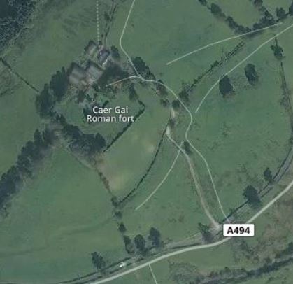
Français : Vue satellite du site de anglo-romain de Caer Gai et le lime en bas à droite. Province du Cheshire. |
| Date | |
| Source | File:CaerGaiSat.jpg |
| Author | Hooligan, 2015 |
Licensing
This file is licensed under the Creative Commons Attribution-Share Alike 3.0 Unported license.
- You are free:
- to share – to copy, distribute and transmit the work
- to remix – to adapt the work
- Under the following conditions:
- attribution – You must give appropriate credit, provide a link to the license, and indicate if changes were made. You may do so in any reasonable manner, but not in any way that suggests the licensor endorses you or your use.
- share alike – If you remix, transform, or build upon the material, you must distribute your contributions under the same or compatible license as the original.
File history
Click on a date/time to view the file as it appeared at that time.
| Date/Time | Thumbnail | Dimensions | User | Comment | |
|---|---|---|---|---|---|
| current | 08:26, 15 June 2018 | | 419 × 406 (30 KB) | Ruyblas13 | User created page with UploadWizard |
File usage
There are no pages that use this file.
Global file usage
The following other wikis use this file:
- Usage on en.wikipedia.org