File:France, Marne, Braux-Saint-Remy.JPG

Size of this preview: 800 × 542 pixels. Other resolutions: 320 × 217 pixels | 640 × 434 pixels | 1,024 × 694 pixels | 1,280 × 868 pixels | 2,100 × 1,424 pixels.
Original file (2,100 × 1,424 pixels, file size: 658 KB, MIME type: image/jpeg)
Summary
| Description |
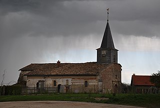
Nederlands: Kerkje van Braux-Saint-Remy in de regen (kanton Sainte-Menehould, departement Marne, regio Champagne-Ardenne, Frankrijk).
Français : Église de Braux-Saint-Remy sous la pluie (canton Sainte-Menehould, département de la Marne, région Champagne-Ardenne, France).
English: Church of Braux-Saint-Remy in the rain (canton Sainte-Menehould, Marne department, Champagne-Ardenne region, France). |
| Date | |
| Source | Own work |
| Author | Vincent van Zeijst |
The church is located at:
| Object location | | View this and other nearby images on: OpenStreetMap |
|---|
Picture taken, looking to the southeast from:
| Camera location | | View this and other nearby images on: OpenStreetMap |
|---|
Licensing
I, the copyright holder of this work, hereby publish it under the following license:
This file is licensed under the Creative Commons Attribution-Share Alike 3.0 Unported license.
- You are free:
- to share – to copy, distribute and transmit the work
- to remix – to adapt the work
- Under the following conditions:
- attribution – You must give appropriate credit, provide a link to the license, and indicate if changes were made. You may do so in any reasonable manner, but not in any way that suggests the licensor endorses you or your use.
- share alike – If you remix, transform, or build upon the material, you must distribute your contributions under the same or compatible license as the original.
File history
Click on a date/time to view the file as it appeared at that time.
| Date/Time | Thumbnail | Dimensions | User | Comment | |
|---|---|---|---|---|---|
| current | 20:35, 4 May 2012 | | 2,100 × 1,424 (658 KB) | Loranchet | {{Information |Description ={{nl|1=Kerkje van Braux-Saint-Remy in de regen (kanton Sainte-Menehould, departement Marne, regio Champagne-Ardenne, Frankrijk).}} {{fr|1=Église de Braux-Saint-Remy sous la pluie (canton Sainte-Menehould, département de... |
File usage
The following 3 pages use this file:
Global file usage
The following other wikis use this file:
- Usage on ast.wikipedia.org
- Usage on ca.wikipedia.org
- Usage on ceb.wikipedia.org
- Usage on ce.wikipedia.org
- Usage on cs.wikipedia.org
- Usage on de.wikipedia.org
- Usage on en.wikipedia.org
- Usage on es.wikipedia.org
- Usage on eu.wikipedia.org
- Usage on fr.wikipedia.org
- Usage on hu.wikipedia.org
- Usage on it.wikipedia.org
- Usage on ku.wikipedia.org
- Usage on la.wikipedia.org
- Usage on lb.wikipedia.org
- Usage on mg.wikipedia.org
- Usage on ms.wikipedia.org
- Usage on nl.wikipedia.org
- Usage on oc.wikipedia.org
- Usage on pl.wikipedia.org
- Usage on pt.wikipedia.org
- Usage on ro.wikipedia.org
- Usage on sh.wikipedia.org
- Usage on sk.wikipedia.org
- Usage on sr.wikipedia.org
- Usage on sv.wikipedia.org
- Usage on tt.wikipedia.org
- Usage on uk.wikipedia.org
- Usage on vec.wikipedia.org
- Usage on zh-min-nan.wikipedia.org