File:Kenmare Stone Circle - geograph.org.uk - 1444795.jpg
No higher resolution available.
Kenmare_Stone_Circle_-_geograph.org.uk_-_1444795.jpg (640 × 419 pixels, file size: 93 KB, MIME type: image/jpeg)
Summary
| Description |
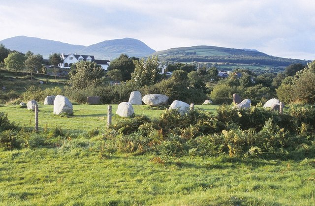
English: Kenmare Stone Circle This stone circle is about 300 metres west of the town centre of Kenmare in an area known as The Shrubberies. It comprises a ring of 15 free-standing stones, 13 upright and 2 prostrate, with a diameter of about 16 metres. These circles are thought to form part of the funerary or ritual tradition of the Bronze Age, dating from between about 2400 BC and 500 BC. |
| Date | |
| Source | From geograph.org.uk |
| Author | Nigel Cox |
| Attribution (required by the license) | Nigel Cox / Kenmare Stone Circle / |
| Camera location | | View this and other nearby images on: OpenStreetMap |
|---|
_heading:315.00&language=en)
| Object location | | View this and other nearby images on: OpenStreetMap |
|---|
_heading:315.00&language=en)
Licensing

|
This image was taken from the Geograph project collection. See this photograph's page on the Geograph website for the photographer's contact details. The copyright on this image is owned by Nigel Cox and is licensed for reuse under the Creative Commons Attribution-ShareAlike 2.0 license.
|
This file is licensed under the Creative Commons Attribution-Share Alike 2.0 Generic license.
Attribution: Nigel Cox
- You are free:
- to share – to copy, distribute and transmit the work
- to remix – to adapt the work
- Under the following conditions:
- attribution – You must give appropriate credit, provide a link to the license, and indicate if changes were made. You may do so in any reasonable manner, but not in any way that suggests the licensor endorses you or your use.
- share alike – If you remix, transform, or build upon the material, you must distribute your contributions under the same or compatible license as the original.
File history
Click on a date/time to view the file as it appeared at that time.
| Date/Time | Thumbnail | Dimensions | User | Comment | |
|---|---|---|---|---|---|
| current | 02:18, 2 March 2011 | | 640 × 419 (93 KB) | GeographBot | == {{int:filedesc}} == {{Information |description={{en|1=Kenmare Stone Circle This stone circle is about 300 metres west of the town centre of Kenmare in an area known as The Shrubberies. It comprises a ring of 15 free-standing stones, 13 upright and 2 pr |
File usage
The following 2 pages use this file:
Global file usage
The following other wikis use this file:
- Usage on ca.wikipedia.org
- Usage on de.wikipedia.org
- Usage on de.wikivoyage.org
- Usage on en.wikipedia.org
- Usage on eo.wikipedia.org