File:Main roads converge - geograph.org.uk - 1028052.jpg
No higher resolution available.
Main_roads_converge_-_geograph.org.uk_-_1028052.jpg (640 × 480 pixels, file size: 74 KB, MIME type: image/jpeg)
Summary
| Description |
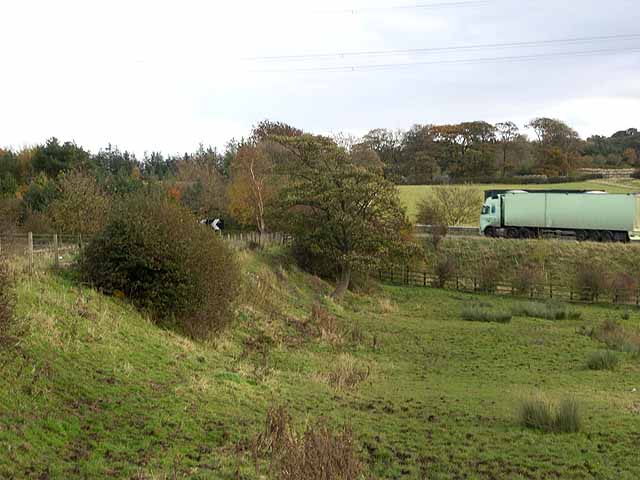
English: Main roads converge At this point the A69 Carlisle to Newcastle and the Military Road, B6318, converge. The Military Road turns left to run parallel for a short way before crossing the dual carriageway by a bridge. Hadrian's Wall National Trail http://www.nationaltrail.co.uk/hadrianswall/ pursues a somewhat indeterminate course into the corner of the field before climbing the bank to the left onto the Military Road |
| Date | |
| Source | From geograph.org.uk |
| Author | Oliver Dixon |
| Attribution (required by the license) | Oliver Dixon / Main roads converge / |
| Camera location | | View this and other nearby images on: OpenStreetMap |
|---|
_heading:112.00&language=en)
| Object location | | View this and other nearby images on: OpenStreetMap |
|---|
_heading:112.00&language=en)
Licensing

|
This image was taken from the Geograph project collection. See this photograph's page on the Geograph website for the photographer's contact details. The copyright on this image is owned by Oliver Dixon and is licensed for reuse under the Creative Commons Attribution-ShareAlike 2.0 license.
|
This file is licensed under the Creative Commons Attribution-Share Alike 2.0 Generic license.
Attribution: Oliver Dixon
- You are free:
- to share – to copy, distribute and transmit the work
- to remix – to adapt the work
- Under the following conditions:
- attribution – You must give appropriate credit, provide a link to the license, and indicate if changes were made. You may do so in any reasonable manner, but not in any way that suggests the licensor endorses you or your use.
- share alike – If you remix, transform, or build upon the material, you must distribute your contributions under the same or compatible license as the original.
File history
Click on a date/time to view the file as it appeared at that time.
| Date/Time | Thumbnail | Dimensions | User | Comment | |
|---|---|---|---|---|---|
| current | 14:44, 23 February 2011 | | 640 × 480 (74 KB) | GeographBot | == {{int:filedesc}} == {{Information |description={{en|1=Main roads converge At this point the A69 Carlisle to Newcastle and the Military Road, B6318, converge. The Military Road turns left to run parallel for a short way before crossing the dual carriage |
File usage
The following 2 pages use this file:
Global file usage
The following other wikis use this file:
- Usage on de.wikipedia.org
- Usage on en.wikipedia.org