File:Saxton Norfolk map Stage II 1583.jpg

Size of this preview: 800 × 559 pixels. Other resolutions: 320 × 223 pixels | 640 × 447 pixels | 1,024 × 715 pixels | 1,280 × 894 pixels | 2,560 × 1,787 pixels | 4,125 × 2,880 pixels.
Original file (4,125 × 2,880 pixels, file size: 2.68 MB, MIME type: image/jpeg)
Summary
| Title |
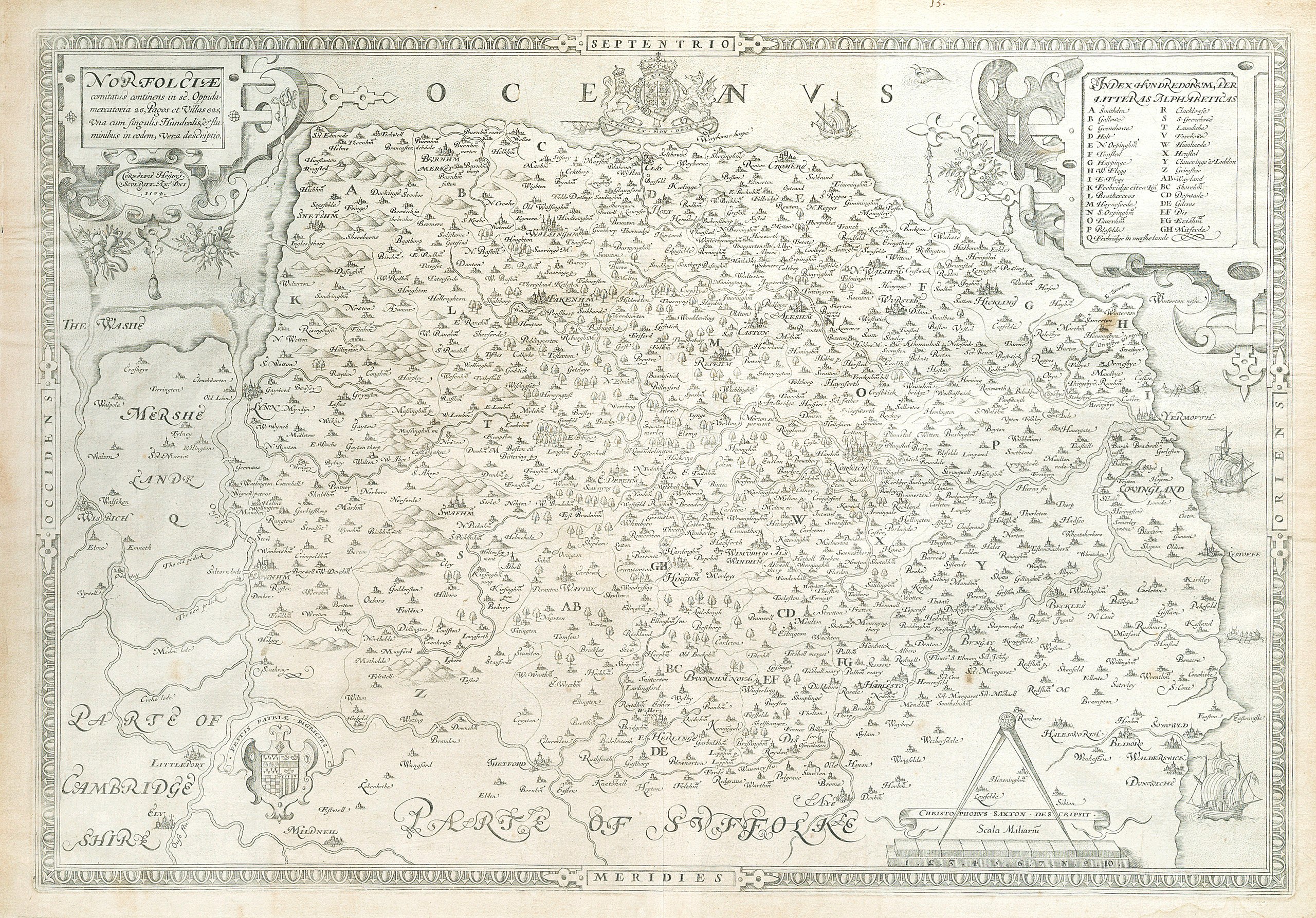
Latina: Norfolciæ comitatus continens in se. Oppida mercatoria 26, pagos et villas 625, una cum singulis hundredis et fluminibus in eodem, vera descriptio. Cornelius Hogius sculpsit. Ano. Dni 1574 |
||||||||||||||||||||||||||||||||||||||
| Description |
English: Map by Christopher Saxton, engraved by Cornelis de Hooghe, revised edition (Lawrence & Evans Stage II) on paper with bunch of grapes watermark, strapwork title cartouche upper left, scale of miles surmounted by open dividers, strapwork cartouche with index of hundreds in upper right corner, arms of Queen Elizabeth and Thomas Seckford, sailing ships and sea monster. Ca. 1583 edition of 1574 map. |
||||||||||||||||||||||||||||||||||||||
| Date | circa 1583 | ||||||||||||||||||||||||||||||||||||||
| Source | Bonham's Image | ||||||||||||||||||||||||||||||||||||||
| Creator |
|
||||||||||||||||||||||||||||||||||||||
| Geotemporal data | |||||||||||||||||||||||||||||||||||||||
| Date depicted | |||||||||||||||||||||||||||||||||||||||
| Map location | Norfolk | ||||||||||||||||||||||||||||||||||||||
| Map type | county map | ||||||||||||||||||||||||||||||||||||||
| Georeferencing | If inappropriate please set warp_status = skip to hide. | ||||||||||||||||||||||||||||||||||||||
| Bibliographic data | |||||||||||||||||||||||||||||||||||||||
| Language | Latin | ||||||||||||||||||||||||||||||||||||||
| Place of publication | London | ||||||||||||||||||||||||||||||||||||||
| Publisher | |||||||||||||||||||||||||||||||||||||||
| Archival data | |||||||||||||||||||||||||||||||||||||||
| Collection | Private collection | ||||||||||||||||||||||||||||||||||||||
| Medium | engraving on paper | ||||||||||||||||||||||||||||||||||||||
| Inscriptions |
Title and date top left: Norfolciæ comitatus continens in se. Oppida mercatoria 26, pagos et villas 625, una cum singulis hundredis et fluminibus in eodem, vera descriptio. Cornelius Hogius sculpsit. Ano. Dni 1574
[County of Norfolk containing within it. 26 merchant towns, 625 villages and hamlets, together with each hundreds and rivers in the same, a true description. Cornelius Hogius engraved it. In the year of our Lord 1574.] Legend top right:
Indexa hundredorum, per litteras alphabeticus
[Alphabetical index of hundreds.] Author bottom right:
Christopherus Saxton descripsit
[Christopher Saxton described [it]]Linear scale bottom rightCoat of arms top centerCoat of arms bottom right |
||||||||||||||||||||||||||||||||||||||
| artwork-references |
|
||||||||||||||||||||||||||||||||||||||
Licensing
|
This work is in the public domain in its country of origin and other countries and areas where the copyright term is the author's life plus 100 years or fewer. | |
| This file has been identified as being free of known restrictions under copyright law, including all related and neighboring rights. | |
This media file is in the public domain in the United States. This applies to U.S. works where the copyright has expired, often because its first publication occurred prior to January 1, 1929, and if not then due to lack of notice or renewal. See this page for further explanation.
|
 | |
 |
This image might not be in the public domain outside of the United States; this especially applies in the countries and areas that do not apply the rule of the shorter term for US works, such as Canada, Mainland China (not Hong Kong or Macao), Germany, Mexico, and Switzerland. The creator and year of publication are essential information and must be provided. See Wikipedia:Public domain and Wikipedia:Copyrights for more details.
|
File history
Click on a date/time to view the file as it appeared at that time.
| Date/Time | Thumbnail | Dimensions | User | Comment | |
|---|---|---|---|---|---|
| current | 22:56, 13 March 2021 | | 4,125 × 2,880 (2.68 MB) | PKM | {{Map |title = {{la|Norfolciæ comitatus continens in se. Oppida mercatoria 26, pagos et villas 625, una cum singulis hundredis et fluminibus in eodem, vera descriptio. Cornelius Hogius sculpsit. Ano. Dni 1574}} |description = {{en|Engraved map by Cornelis de Hooghe after Christopher Saxton, early issue (Lawrence & Evans Stage II) with bunch of grapes watermark, strapwork title cartouche in upper left-hand corner, scale of distance surmounted by open dividers, strapwork car... |
File usage
The following 3 pages use this file: